Civil parish · Maidstone · E04013400
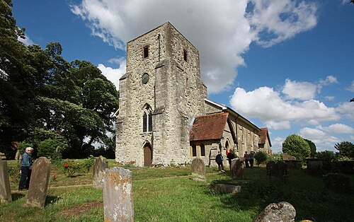
Photo: John Salmon · CC BY-SA 2.0 · Wikimedia Commons
Chart Sutton
935 people lived here at the 2021 census, up 7.5% on 2011. It has 39 listed buildings.
- District
- Maidstone
- Status
- Civil parish
- Size rank
- 225 of 364
- Grid
- 51.224°N, 0.571°E
01
Census
Population, 2001 to 2021
8222001
8702011
9352021
Source: Office for National Statistics census figures as recorded in Wikidata.
02
Heritage
39 listed buildings
Most common types: farmhouse, cottage, barn, hop kiln, house, gatehouse.
0Grade I
1Grade II*
38Grade II
0Scheduled
Grade II*
Dunbury Farmhousefarmhouse · List entry 1060947
Grade II
Ashurst Farmhousefarmhouse · List entry 1344279
Ashurst Lodge Farmhousefarmhouse · List entry 1348509
Barn About 2 1/2 Metres South West Of Chart Hall Farmhousebarn · List entry 1083584
Barn About 24 Metres South West Of Elderden Farmhousebarn · List entry 1347886
Barn About 40 Metres South South West Of Park House Farmhousebarn · List entry 1338869
Barns And Outbuildings To North East Of Fir Tree Farmhousebarn · List entry 1060914
Chart Hall Farmhousefarmhouse · List entry 1344283
Chart Placelisted building · List entry 1344282
Chart Place Cottagescottage · List entry 1347780
Church of St Michaelchurch building · List entry 1060948
Court Farmhouse And Barnfarmhouse · List entry 1060949
Elderden Farmhousefarmhouse · List entry 1060946
Former Granary About 15 Metres North Of Chart Place Cottagesgranary · List entry 1101729
Garage At Fir Tree Farmhousegarage · List entry 1259305
Herondenlisted building · List entry 1344281
House Attached To North Of Post Office Storeshouse · List entry 1347900
Ivy Cottagecottage · List entry 1101511
Ladds Courtlisted building · List entry 1344280
Lake Farmhousefarmhouse · List entry 1344284
Lested Lodgegatehouse · List entry 1060913
Little Ashurstlisted building · List entry 1060945
Lucks Cottagecottage · List entry 1060912
Marshalls Placelisted building · List entry 1060944
Mounting Block About 20 Metres West North West Of Church Of St Michaellisted building · List entry 1101741
Newhouse Farmhousefarmhouse · List entry 1344305
Norton Courtlisted building · List entry 1060950
Oasthouse About 17 Metres East Of Fir Tree Farmhousehop kiln · List entry 1060915
Oasthouse Range About 17 Metres East North East Of Ashurst Courthop kiln · List entry 1347902
Old Amber Green Farmhousefarmhouse · List entry 1100333
Old Farmhouse, Moat Farmlisted building · List entry 1101736
Outbuilding about 80 metres south of Church of St Michaeloutbuilding
Priory Househouse · List entry 1060919
Rectory Farmhousefarmhouse · List entry 1060918
Stable To South Of Rectory Farmhousestable · List entry 1251116
Sutton Platt Cottagecottage · List entry 1060917
The Mooringslisted building · List entry 1060916
Wentwayslisted building · List entry 1344304
White House Farmhousefarmhouse · List entry 1060951
Source: National Heritage List for England entries recorded in Wikidata with this parish or town as location.
Neighbours
Twinned with
No twinning recorded.