- Home
- Tunbridge Wells
- Frittenden
Civil parish · Tunbridge Wells · E04005121
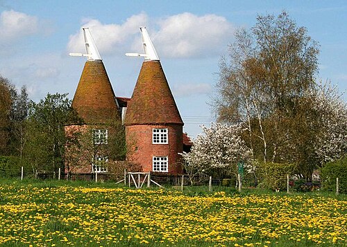
Photo: Val Vannet · CC BY-SA 2.0 · Wikimedia Commons
Frittenden
894 people lived here at the 2021 census, up 0.7% on 2011. It has 64 listed buildings.
- District
- Tunbridge Wells
- Status
- Civil parish
- Size rank
- 235 of 364
- Grid
- 51.141°N, 0.593°E
01
Census
Population, 2001 to 2021
8672001
8882011
8942021
Source: Office for National Statistics census figures as recorded in Wikidata.
02
Heritage
64 listed buildings
Most common types: farmhouse, house, hop kiln, cottage, barn, wall.
0Grade I
4Grade II*
60Grade II
0Scheduled
Grade II*
Balcombe Farmhousefarmhouse · List entry 1338652
Church of St Marychurch building · List entry 1116253
Great Bubhurstlisted building · List entry 1084760
Ponds Farmhousefarmhouse · List entry 1186236
Grade II
Barn About 25 Metres North West Of Catherine Wheelbarn · List entry 1116309
Barn And Attached Sheds 10 Metres West Of Little Bubhurstbarn · List entry 1084761
Barn And Handpump Attached, About 10 Metres South Of Broadlakebarn · List entry 1084736
Beal Farmhousefarmhouse · List entry 1338677
Bell And Jorrocks Public Housepub · List entry 1338650
Brissenden Farmhousefarmhouse · List entry 1116281
Broadlakelisted building · List entry 1116329
Brook Farmhousefarmhouse · List entry 1338674
Burnt Househouse · List entry 1116161
Catherine Wheellisted building · List entry 1338676
Charity Cottagescottage · List entry 1116521
Cherry Tree Farmhousefarmhouse · List entry 1338672
Cole Farmlisted building · List entry 1084771
Corner Farmhousefarmhouse · List entry 1084767
Forge Househouse · List entry 1084763
Foxearth Cottagecottage · List entry 1084745
Frittenden Schoollisted building · List entry 1116159
Frittenden Stores Manchester Househouse · List entry 1084762
Gatehousegatehouse · List entry 1084740
Gould Farmhousefarmhouse · List entry 1084734
Granary/Outbuilding About 10 Metres East Of Cole Farmhousegranary · List entry 1084731
Great Hungerden Cottagescottage · List entry 1116491
Lake Househouse · List entry 1116298
Lashenden Farmhousefarmhouse · List entry 1338648
Limberlostlisted building · List entry 1084733
Little Brookwoodlisted building · List entry 1084770
Little Brookwood Granarylisted building · List entry 1084546
Little Bubhurstlisted building · List entry 1338649
Lowland Farm House And Walled Forecourtfarmhouse · List entry 1084737
Lychgate And Quadrant Walls, About 40 Metres South Off Church Of St Marylychgate · List entry 1320048
Manor Farmhousefarmhouse · List entry 1338651
Maplehurst Mill Househouse · List entry 1338675
Monument To Reverend Edward Moore, About 25 Metres South Of Church Of St Marymonument · List entry 1084741
Oast About 25 Metres North Of Stone Court Farmhousehop kiln · List entry 1084765
Oasthouse About 20 Metres South East Of Cherry Tree Farmhousehop kiln · List entry 1084732
Oasthouse About 25 Metres East Of Sandhurst Bridge Farmhousehop kiln · List entry 1084738
Oasthouse About 25 Metres North Of Weaver's Denhop kiln · List entry 1116548
Oasthouse About 75 Metres South West Of Cherry Tree Farmhousehop kiln · List entry 1338673
Oasthouse And Barn About 15 Metres South Of Manor Farmhousehop kiln · List entry 1084764
Park Farm Housefarmhouse · List entry 1084744
Poplar Househouse · List entry 1084739
Providence Chapel And Housechapel · List entry 1186207
Rock Farm Housefarmhouse · List entry 1116339
Ryecotlisted building · List entry 1320028
Sandhurst Bridge Farmhousefarmhouse · List entry 1320006
Sinkhurst Green Cottagescottage · List entry 1320025
Stone Court Farmhousefarmhouse · List entry 1186220
Street Farm Cottage Street Farmhousefarmhouse · List entry 1338681
Sundial About 30 Metres South Of Church Of St Marysundial · List entry 1116235
The Mitchellslisted building · List entry 1186257
The Old Manormanor house · List entry 1338678
Three Chest Tombs About 1 To 6 Metres East Of Church Of St Marychest tomb · List entry 1084742
Tilebarn Cottagescottage · List entry 1084759
Tolehurst Farmhousefarmhouse · List entry 1116163
Townsend Cottagescottage · List entry 1084769
Wall And Outhouse Attached To Ryecotwall · List entry 1338679
Wall And Outhouse Attached To Well Housewall · List entry 1116217
Weaver's Denlisted building · List entry 1084768
Well And Housing About 10 Metres East Of Well Housewater well · List entry 1084743
Well Househouse · List entry 1338680
Source: National Heritage List for England entries recorded in Wikidata with this parish or town as location.
03
Schools
1 school nearby
Open schools from the DfE register addressed in Frittenden, or whose nearest town or parish centre in Tunbridge Wells is Frittenden.
| School | Phase | Ages | Pupils | Intake |
|---|---|---|---|---|
| Frittenden Church of England Primary School | Primary | 4–11 | 100 | Mixed |
Neighbours
Twinned with
No twinning recorded.