Civil parish · Maidstone · E04004958
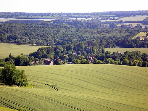
Photo: Sarepava · CC BY-SA 3.0 · Wikimedia Commons
Hollingbourne
1,024 people lived here at the 2021 census, up 7.9% on 2011. It has 77 listed buildings, 2 of them Grade I.
- District
- Maidstone
- Status
- Civil parish
- Size rank
- 223 of 364
- Postcode
- ME17
- Grid
- 51.267°N, 0.641°E
- Council
- www.hollingbournepc.kentpar…
01
Census
Population, 2001 to 2021
8582001
9492011
1,0242021
Source: Office for National Statistics census figures as recorded in Wikidata.
02
Heritage
77 listed buildings and 2 scheduled monuments
Most common types: cottage, house, farmhouse, table tomb, wall, pub.
2Grade I
3Grade II*
72Grade II
2Scheduled
Grade I
All Saints Church, Hollingbournechurch building · List entry 1203836
Hollingbourne ManorEnglish country house · List entry 1203946
Grade II*
Godfrey Househouse · List entry 1054873
Greenway Forstal Farmhousefarmhouse · List entry 1299691
Malt Househouse · malt house · List entry 1344363
Grade II
20 And 22, Eyhorne Streetlisted building · List entry 1060793
34-40, Eyhorne Streetlisted building · List entry 1374144
42-46, Eyhorne Streetlisted building · List entry 1344358
50 And 52, Eyhorne Streetlisted building · List entry 1060796
57,59,61, Eyhorne Streetlisted building · List entry 1060829
6-16, Eyhorne Streetlisted building · List entry 1344356
64 And 66, Eyhorne Streetlisted building · List entry 1031382
April Cottage Beaufort Cottage Fern Cottagecottage · List entry 1060794
Autumn Cottagecottage · List entry 1344361
Bank Cottagescottage · List entry 1025853
Barn About 10 Metres South West Of Greenway Forstal Farmhousebarn · List entry 1344360
Broad Street Farmhousefarmhouse · List entry 1054898
Brushings Cottagecottage · List entry 1367032
Brushings Farmhousefarmhouse · List entry 1054896
Coachmans Cottagecottage · List entry 1060827
Cotuams Househouse · List entry 1060791
Donkey Wheel About 70 Metres North West Of Hollingbourne Houselisted building · List entry 1025848
Elm Cottagecottage · List entry 1367083
Eyhorne Manormanor house · List entry 1060826
Forge Cottagescottage · List entry 1060801
Foxgrove Househouse · List entry 1344357
Garden Wall About 3 Metre East Of Base Of North Wing Of Hollingbourne Manorwall · List entry 1344347
Garden Wall About 3 Metres East Of South Wing Of Hollingbourne Manorwall · List entry 1060808
Garden Wall And Gatepier About 20 Metres To North North East Of Cotauams Housewall · List entry 1060792
Gazebo About 100 Metres North West Of Hollingbourne Housegazebo · List entry 1060799
Glyder House Sugar Loaves Public Housepub · List entry 1031373
Greenway Cottagecottage · List entry 1025878
Greenway Courtlisted building · List entry 1060798
Grove Househouse · List entry 1060803
Hollingbourne Househouse · List entry 1025842
Hollingbourne War Memorialmemorial · List entry 1415052
Lilac Cottagecottage · List entry 1060828
Malt Cottagecottage · List entry 1281525
Manor Farmhousefarmhouse · List entry 1060807
Mantels Farmhousefarmhouse · List entry 1354765
Marshalls Farmagricultural structure · List entry 1344362
Meadow Way Cottage Poste Cottage Small Meadcottage · List entry 1054849
Mill Househouse · List entry 1203911
Niton Househouse · List entry 1344339
Oakfieldlisted building · List entry 1367038
Old England Cottagecottage · List entry 1060822
Park Mill Househouse · List entry 1336281
Penn Courtlisted building · List entry 1344329
Pilgrims Cottagescottage · List entry 1344337
Ripple Farmhousefarmhouse · List entry 1367051
River Farmhousefarmhouse · List entry 1060789
Sandhurstlisted building · List entry 1344336
Six Bells Cottagecottage · List entry 1060804
Smiths Farmhousefarmhouse · List entry 1060800
Snagbrooklisted building · List entry 1344359
Table tomb about 2 metres north of porch of Church of All Saintstable tomb · List entry 1060806
Table tomb about 2.5 metres east of vestry of Church of All Saintstable tomb · List entry 1203889
Table tomb about 22 metres south of Church of All Saintstable tomb · List entry 1344328
Table tomb about 6 metres south of Church of All Saintstable tomb · List entry 1281484
Table tomb to Edward Charlton about 2.5 metres south of Church of All Saintstable tomb · List entry 1060805
Table tomb to Richard Thomas about 43 metres south of Church of All Saintstable tomb · List entry 1281481
Tanyard Househouse · List entry 1060797
The Old China Shop, Cootage Adjoining To The Right And The Limeletlisted building · List entry 1054832
The Old Cottagecottage · List entry 1344327
The Old Forgesmithy · List entry 1060772
The Old Househouse · List entry 1060824
The Old Vicarageclergy house · List entry 1315890
The Pilgrims Rest Inninn · List entry 1203811
The Windmill Public Housepub · List entry 1060795
Tile Barn Cottagescottage · List entry 1149363
Vine Cottage And Cottage Adjoiningcottage · List entry 1344340
Wall Bounding South-East Side Of Eyhorne Street Starting About 10 Metres West Of Cotuams Housewall · List entry 1060790
Wayfarerslisted building · List entry 1060825
Whitehalllisted building · List entry 1344338
Wimborne Househouse · List entry 1060788
Woodcut Farmhousefarmhouse · List entry 1045814
Woodgate Yew Treeslisted building · List entry 1025306
Scheduled monuments
Hollingbourne Second World War Zero Stationbunker · underground structure · List entry 1479310
Medieval moated site, Ripple Manormoated site · List entry 1017548
Source: National Heritage List for England entries recorded in Wikidata with this parish or town as location.
03
Schools
1 school nearby
Open schools from the DfE register addressed in Hollingbourne, or whose nearest town or parish centre in Maidstone is Hollingbourne.
| School | Phase | Ages | Pupils | Intake |
|---|---|---|---|---|
| Hollingbourne Primary School | Primary | 4–11 | 96 | Mixed |
Neighbours
Twinned with
No twinning recorded.