Civil parish · Ashford · E04004861
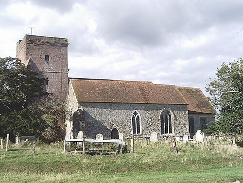
Photo: David Kemp · CC BY-SA 2.0 · Wikimedia Commons
Warehorne
337 people lived here at the 2021 census, down 8.9% on 2011. It has 35 listed buildings, 1 of them Grade I.
- District
- Ashford
- Status
- Civil parish
- Size rank
- 307 of 364
- Area
- 10.7 km²
- Postcode
- TN26
- Grid
- 51.061°N, 0.835°E
01
Census
Population, 2001 to 2021
3742001
3702011
3372021
Source: Office for National Statistics census figures as recorded in Wikidata.
02
Heritage
35 listed buildings and 1 scheduled monument
Most common types: farmhouse, tombstone, house, cottage, chest tomb, church building.
1Grade I
1Grade II*
33Grade II
1Scheduled
Grade I
Church of St Matthewchurch building · List entry 1071183
Grade II*
Leacon Hallhouse · List entry 1185579
Grade II
1-4, the Greenlisted building · List entry 1071932
Bluebell Cottagecottage · List entry 1185557
Burr Farmhousefarmhouse · List entry 1071934
Chest Tomb About 50 Metres South West Of Church Of St Matthewchest tomb · List entry 1185542
Chest Tomb And Headstone 1 To 3 Metres South Of Church Of St Matthewtombstone · chest tomb · List entry 1185513
Chest Tomb And Headstone About 15 Metres South West Of Church Of St Matthewtombstone · chest tomb · List entry 1185535
Chest Tomb To Hodges Family, About 15 Metres South Of Church Of St Matthewchest tomb · List entry 1071184
Chest Tomb To Hodges Family, About 2 Metres South Of Church Of St Matthewchest tomb · List entry 1362801
Church Farmhousefarmhouse · List entry 1185445
Churchfield Terracelisted building · List entry 1185575
Gold Househouse · List entry 1362433
Ham Mill Greenlisted building · List entry 1362432
Hatch Farmhousefarmhouse · List entry 1362799
Headstone To Margaret Burges, About 4 Metres South Of Church Of St Matthewtombstone · List entry 1185520
Headstone To Richard Jervis, About 10 Metres South West Of Church Of St Matthewtombstone · List entry 1071185
House 30 Metres West Of Stone Farmhousehouse · List entry 1185560
Keepers Cottage Middle Plattcottage · List entry 1299614
Leacon Farmhousefarmhouse · List entry 1185595
Lilyfieldslisted building · List entry 1362394
Lordenslisted building · List entry 1071936
Mill Househouse · List entry 1071937
Mountfieldlisted building · List entry 1362800
Oasthouse About 25 Metres North West Of Burr Farmhousehop kiln · List entry 1185582
Parsonage Farmhousefarmhouse · List entry 1185403
Pilgrims Cottagescottage · List entry 1071933
Spot House Farmhousefarmhouse · List entry 1071181
Spring Cottagescottage · List entry 1071935
Stone Farmhousefarmhouse · List entry 1362431
The Leaconlisted building · List entry 1185587
The Woolpack Innpub · inn · List entry 1185431
Tintonlisted building · List entry 1071931
Tucker's Farmhousefarmhouse · List entry 1071182
Two Headstones To Down Family About 20 Metres South West Of Church Of St Matthewtombstone · List entry 1362802
Scheduled monuments
Royal Military Canal, Kenardington Bridge to Warehorne Bridgecanal · List entry 1005125
Source: National Heritage List for England entries recorded in Wikidata with this parish or town as location.
Neighbours
Twinned with
No twinning recorded.