Civil parish · Ashford · E04012786
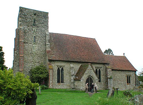
Photo: John Salmon · CC BY-SA 2.0 · Wikimedia Commons
Kingsnorth
12,024 people lived here at the 2021 census, up 6.9% on 2011. It has 30 listed buildings, 1 of them Grade I.
- District
- Ashford
- Status
- Civil parish
- Size rank
- 33 of 364
- Area
- 12.5 km²
- Grid
- 51.118°N, 0.862°E
01
Census
Population, 2001 to 2021
6,7092001
11,2432011
12,0242021
Source: Office for National Statistics census figures as recorded in Wikidata.
02
Heritage
30 listed buildings and 1 scheduled monument
Most common types: farmhouse, cottage, house, hop kiln, church building, archaeological site.
1Grade I
0Grade II*
29Grade II
1Scheduled
Grade I
Church of St Michaelchurch building · List entry 1362667
Grade II
Barn To South Of Old Mumford Farmhousebarn · List entry 1115433
Bond Farmhousefarmhouse · List entry 1115501
Brisley Farmhousefarmhouse · List entry 1071463
Cloverley Cottagecottage · List entry 1362632
Finn Farmhousefarmhouse · List entry 1071467
Glebe Cottagecottage · List entry 1071464
Glenmore Lodgegatehouse · List entry 1320389
Houghton Househouse · List entry 1071469
Mill Househouse · List entry 1071462
Mouse Halllisted building · List entry 1115481
Mumford Cottagecottage · List entry 1071465
Mumford Househouse · List entry 1320415
Oasthouse To North West Of Finn Farmhousehop kiln · List entry 1115435
Oasthouse To West Of Finn Farmhousehop kiln · List entry 1362631
Old Mumford Farmhousefarmhouse · List entry 1362669
Pickendenlisted building · List entry 1320421
Piran Cottagecottage · List entry 1115476
Pondervillelisted building · List entry 1071470
Pound Farmhousefarmhouse · List entry 1320407
Pound Greenlisted building · List entry 1320408
Queen's Head Public Housepub · List entry 1071466
Shipley Hatchlisted building · List entry 1320382
Sticketts Farmhousefarmhouse · List entry 1320439
Taylor Farmhousefarmhouse · List entry 1362666
Weatherboarded Barn To North Of Finn Farmhouselisted building · List entry 1071468
Weatherboarded Barn To North West Of Smithfield Farmhousethatched barn · List entry 1320438
Whitegateslisted building · List entry 1362668
Willowbed Farmhousefarmhouse · List entry 1320433
Wix's Farmhousefarmhouse · List entry 1071461
Scheduled monuments
Romano-British roadside settlement and World War II pillbox immediately east of Westhawk Farmarchaeological site · List entry 1017645
Source: National Heritage List for England entries recorded in Wikidata with this parish or town as location.
03
Schools
4 schools nearby
Open schools from the DfE register addressed in Kingsnorth, or whose nearest town or parish centre in Ashford is Kingsnorth.
| School | Phase | Ages | Pupils | Intake |
|---|---|---|---|---|
| Furley Park Primary Academy | Primary | 4–11 | 504 | Mixed |
| Kingsnorth Church of England Primary School | Primary | 4–11 | 419 | Mixed |
| The John Wallis Church of England Academy | All-through | 0–19 | 1,650 | Mixed |
| Kings Park School grammar | Other independent special school | 7–16 | 5 | Mixed |
Neighbours
Twinned with
No twinning recorded.