Civil parish · Ashford · E04013234
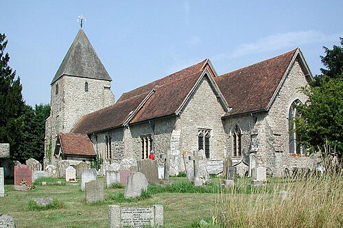
Photo: John Salmon · CC BY-SA 2.0 · Wikimedia Commons
Mersham
1,479 people lived here at the 2021 census, up 31.6% on 2011. It has 74 listed buildings, 3 of them Grade I.
- District
- Ashford
- Status
- Civil parish
- Size rank
- 186 of 364
- Area
- 13.8 km²
- Postcode
- TN25
- Grid
- 51.119°N, 0.934°E
01
Census
Population, 2001 to 2021
1,0582001
1,1242011
1,4792021
Source: Office for National Statistics census figures as recorded in Wikidata.
02
Heritage
74 listed buildings and 1 scheduled monument
Most common types: cottage, house, farmhouse, stable, barn, manor house.
3Grade I
6Grade II*
65Grade II
1Scheduled
Grade I
Church of St John the Baptistchurch building · List entry 1276693
Mersham Le HatchEnglish country house · List entry 1233748
Mersham Manormanor house · List entry 1233281
Grade II*
Barn About 30 Metres North West Of Mersham Manorbarn · List entry 1233497
Bower Farmhousefarmhouse · List entry 1276692
Mill House Swanton Milllisted building · List entry 1276466
Newhouselisted building · List entry 1276324
Stonegreen Hallhouse · List entry 1233498
Stoneleeslisted building · List entry 1233761
Grade II
15, The Streetlisted building · List entry 1234028
16 And 16A, The Streetlisted building · List entry 1234077
Barn About 75 Metres South East Of Quarringtonbarn · List entry 1233694
Barn and attached cowshed at Cheeseman's Green Farmlisted building · List entry 1452767
Barn/Garage About 20 Metres West Of Redburbarn · List entry 1233753
Bell Househouse · List entry 1233520
Bockham Farm Cottagecottage · List entry 1233696
Bower Cottagescottage · List entry 1234027
Bridge Househouse · List entry 1276697
Brook Cottagecottage · List entry 1233524
Burgatelisted building · List entry 1234030
Cheeseman's Green Farmhouselisted building · List entry 1451263
Chequer Tree Farmhousefarmhouse · List entry 1233526
Chest Tomb To Jane Morris (?) About 1 Metre South Of Church Of St Johnchest tomb · List entry 1276631
Chestnut Villaslisted building · List entry 1234025
Coachhouse And Garden Walls Attached, About 10 Metres To East And South Of Burgatecarriage house · List entry 1234031
Collier Hill Cottagecottage · List entry 1276581
Denne And Projecting Wallslisted building · List entry 1276579
Elm Tree Farmhousefarmhouse · List entry 1233766
Flanders Househouse · List entry 1233758
Gains Cottagecottage · List entry 1276469
Garden Walls To West And North West Of Newhousewall · List entry 1234024
Gill Cottagecottage · List entry 1233686
Glebe House And Wall Attachedlisted building · List entry 1034444
Goodrich Cottagecottage · List entry 1233657
Granary Cottagecottage · List entry 1233509
Hannover Mill, Outbuildings And Millmill building · List entry 1233522
Hatch Cottage Little Hatchcottage · List entry 1234032
Hatch Lodgegatehouse · List entry 1276485
Headstone To George Blechynden, About 4 Metres South East Of Church Of St Johntombstone · List entry 1276694
K6 Telephone KioskK6 telephone box · List entry 1393295
Kingsford Hallhouse · List entry 1233751
Little Gill Farmhousefarmhouse · List entry 1276500
Little Stonegreenlisted building · List entry 1233506
Little Swantonlisted building · List entry 1233273
Long Rowlisted building · List entry 1233288
Longthorne Farmhousefarmhouse · List entry 1276460
Loud Househouse · List entry 1233274
Milestone At Tr 045 412milestone · List entry 1276471
Mundy Farmhousefarmhouse · List entry 1233276
Mundy Manormanor house · List entry 1233275
Oasthouse About 75 Metres South East Of Quarringtonhop kiln · List entry 1233695
Outbuilding About 50 Metres North Of Little Stonegreenoutbuilding · List entry 1276571
Outhouse, About 25 Metres South Of Swanton Millouthouse · List entry 1233992
Quarringtonlisted building · List entry 1233688
Ransley Cottagecottage · List entry 1233755
Redburlisted building · List entry 1276462
Sheds, About 50 Metres South East Of Quarringtonlisted building · List entry 1233692
Stable Block About 20 Metres South East Of Woods Storesstable · List entry 1276327
Stable Block About 50 Metres South East Of Quarrington With Wall Attachedstable · List entry 1233690
Stable Block And Gardeners Cottage, Newhousestable · List entry 1234049
Stable/Storage And Wall Attached About 30 Metres North East Of Little Stonegreenstable · List entry 1233287
Stables About 20 Metres North East Of Little Stonegreenstable · List entry 1276698
Stables/Outbuildings About 5 To 20 Metres South And West Of The Farriers Armsstable · List entry 1276525
Stonegreen Cottagecottage · List entry 1233284
Sundial 5 Metres South Of Church Of St Johnsundial · List entry 1276638
The Farriers Armspub · List entry 1233523
The Grangelisted building · List entry 1234023
The Old Gate House Including Attached Raised Footwaylisted building · List entry 1233759
The Royal Oak And House/Office Attachedlisted building · List entry 1234070
Tomb Chest To Elizabeth Mantel, About 20 Metres South Of Church Of St Johntomb · List entry 1233473
Two Rows Of 3 And 5 Headstones About 5 To 15 Metres South Of Church Of St Johntombstone · List entry 1276695
Wall About 10 To 20 Metres South And East Of Quarringtonwall · List entry 1233689
Winser Cottagecottage · List entry 1233756
Woods Stores, Post Office And Hollyhock Cottagecottage · List entry 1234067
Scheduled monuments
Medieval moated site, Quarrington Manormoated site · List entry 1017538
Source: National Heritage List for England entries recorded in Wikidata with this parish or town as location.
03
Schools
1 school nearby
Open schools from the DfE register addressed in Mersham, or whose nearest town or parish centre in Ashford is Mersham.
| School | Phase | Ages | Pupils | Intake |
|---|---|---|---|---|
| Mersham Primary School | Primary | 4–11 | 140 | Mixed |
Neighbours
Twinned with
No twinning recorded.