Civil parish · Ashford · E04004824
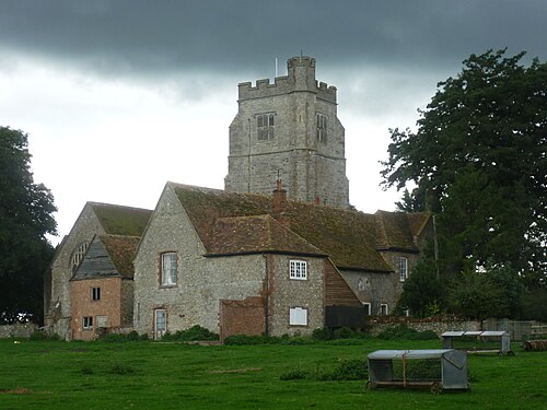
Photo: Marathon · CC BY-SA 2.0 · Wikimedia Commons
Aldington
1,456 people lived here at the 2021 census, up 16.7% on 2011. It has 52 listed buildings, 1 of them Grade I.
- District
- Ashford
- Status
- Civil parish
- Size rank
- 190 of 364
- Area
- 13.5 km²
- Postcode
- TN25
- Grid
- 51.094°N, 0.941°E
01
Census
Population, 2001 to 2021
9812001
1,2482011
1,4562021
Source: Office for National Statistics census figures as recorded in Wikidata.
02
Heritage
52 listed buildings and 2 scheduled monuments
Most common types: farmhouse, cottage, house, barn, agricultural structure, archaeological site.
1Grade I
3Grade II*
48Grade II
2Scheduled
Grade I
Church of St Martinchurch building · List entry 1071208
Grade II*
Cobb's Halllisted building · List entry 1184555
Court Lodge Farmhousefarmhouse · List entry 1071209
Ruffyn's Hill Farmhouse And Walls Projectingfarmhouse · List entry 1184521
Grade II
1 and 2, Clap Hilllisted building · List entry 1184334
Bank Farmhouse And Walls Attachedfarmhouse · List entry 1362752
Barn About 20 Metres East Of Ruffyn's Hill Farmhousebarn · List entry 1071225
Barn About 30 Metres North West Of Hogben Farmhousebarn · List entry 1300208
Barn And 2 Stable Ranges Attached, About 20 Metres North Of Bank Farmhousebarn · List entry 1071248
Barn And Cartsheds About 50 Metres South West Of Court Lodge Farmhousebarn · List entry 1362776
Barton Farmagricultural structure · List entry 1362781
Belarica Cottage Beulahlisted building · List entry 1071226
By The Waylisted building · List entry 1184361
Cherry Orchardlisted building · List entry 1362774
Church Farmhousefarmhouse · List entry 1071211
Church Hill Cottagecottage · List entry 1184281
Clap Hill House Harold Cottagescottage · List entry 1071216
Copperhurstlisted building · List entry 1071223
Falconhurst Farmhousefarmhouse · List entry 1071247
Forehead Farmhousefarmhouse · List entry 1362779
Former Dairy Building About 25 Metres North West Of Hogben Farmhouselisted building · List entry 1071213
Goldenhurst Manormanor house · List entry 1071221
Goldenhurst, The Old Househouse · List entry 1071222
Goldwelllisted building · List entry 1184459
Goodwin Farmhousefarmhouse · List entry 1300136
Granary/Stowage About 35 Metres North East Of Ruffyn's Hill Farmhousegranary · List entry 1362782
Grove Cottagecottage · List entry 1071212
Hand Pump About 5 Metres West Of Quested's Cottagelisted building · List entry 1071219
Hogben Farmhousefarmhouse · List entry 1362778
Hogben Househouse · List entry 1071214
Homelandslisted building · List entry 1071218
Little Copperhurstlisted building · List entry 1300109
Lychgate And Quadrant Walls Attached To Churchyard Of St Martinlychgate · List entry 1362775
Oak Househouse · List entry 1300182
Oast House About 50 Metres West Of Poulton Farmhousehop kiln · List entry 1300148
Parsonage Farmhousefarmhouse · List entry 1071207
Pattisons Farmhousefarmhouse · List entry 1300112
Poulton Farmhousefarmhouse · List entry 1071220
Quested's Cottagecottage · List entry 1184383
Shepherd's Cottage Shepherd's Househouse · List entry 1071217
St Martin's Cottagecottage · List entry 1300185
Stable/Barn About 50 Metres West Of Court Lodge Farmhouselisted building · List entry 1071210
Stable/Outhouse About 10 Metres North Of Goldwellstable · List entry 1362780
Stable/Stock House About 20 Metres North East Of Ruffyn's Hill Farmhouseagricultural structure · List entry 1184539
Stock Yard And Sheds About 75 Metres West Of Court Lodge Farmhouseagricultural structure · List entry 1362777
Street Farmhousefarmhouse · List entry 1071215
Symnel Cottagecottage · List entry 1362753
Symnells And Walled Forecourtlisted building · List entry 1184484
The Old Cottagecottage · List entry 1071249
Tickner Cottagecottage · List entry 1184279
Walnut Tree Innpub · inn · List entry 1300164
Wykhurstlisted building · List entry 1071224
Scheduled monuments
Aldington Knoll Roman barrow and later beaconarchaeological site · List entry 1012216
Romano-British building S of Burch's Rougharchaeological site · List entry 1004216
Source: National Heritage List for England entries recorded in Wikidata with this parish or town as location.
03
Schools
1 school nearby
Open schools from the DfE register addressed in Aldington, or whose nearest town or parish centre in Ashford is Aldington.
| School | Phase | Ages | Pupils | Intake |
|---|---|---|---|---|
| Aldington Primary School | Primary | 4–11 | 198 | Mixed |
Neighbours
Twinned with
No twinning recorded.