- Home
- Tonbridge and Malling
- Plaxtol
Civil parish · Tonbridge and Malling · E04005104
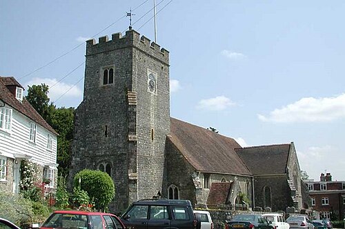
Photo: John Salmon · CC BY-SA 2.0 · Wikimedia Commons
Plaxtol
1,134 people lived here at the 2021 census, up 1.5% on 2011. It has 68 listed buildings, 2 of them Grade I.
- District
- Tonbridge and Malling
- Status
- Civil parish
- Size rank
- 215 of 364
- Grid
- 51.259°N, 0.295°E
01
Census
Population, 2001 to 2021
9692001
1,1172011
1,1342021
Source: Office for National Statistics census figures as recorded in Wikidata.
02
Heritage
68 listed buildings and 2 scheduled monuments
Most common types: cottage, farmhouse, house, barn, hop kiln, agricultural structure.
2Grade I
5Grade II*
61Grade II
2Scheduled
Grade I
Fairlawnehouse · List entry 1072711
Old Soar Manormanor house · historic house museum · List entry 1281122
Grade II*
Clakkers Hallhouse · List entry 1281020
Plaxtol Churchchurch building · List entry 1072684
Rats Castlehouse · List entry 1362027
Spoute Househouse · List entry 1204588
The Grangelisted building · List entry 1072687
Grade II
1-3 Church Rowcottage · List entry 1204667
4 and 5 Church Rowcottage · List entry 1072693
6 and 7 Church Rowcottage · List entry 1204700
Ashenden And Garden Walllisted building · List entry 1072712
Baldwin Family Tomb In Plaxtol Churchyard 20 Yards North Of West Endlisted building · List entry 1204484
Barn 30 Yards To The East Of Dux Farmhousebarn · List entry 1204507
Barn 30 Yards To The East Of Lower Roughway Farmhousebarn · List entry 1204727
Barn 30 Yards To The East Of Old Allensbarn · List entry 1072680
Barn And Oast House 20 Yards To The East Of The Grangebarn · hop kiln · List entry 1204540
Barton's Cottagescottage · List entry 1204604
Bartons Farmhousefarmhouse · List entry 1204953
Bourne Cottagecottage · List entry 1072686
Broadfield Farmhousefarmhouse · List entry 1204647
Buddleia Cottage Old Well Househouse · List entry 1072683
Buttons Bourne Farmhousefarmhouse · List entry 1072682
Church Cottage Club Cottagecottage · List entry 1362024
Church House The Old Post Officepost office · List entry 1362059
Claygate Househouse · List entry 1362034
Cottage 10 Yards To The South Of Bartons Farmhousecottage · List entry 1072714
Croucher's Cottagecottage · List entry 1072696
Crowhurst Farmhousefarmhouse · List entry 1204498
Dux Farmhousefarmhouse · List entry 1362060
Elm Tree Cottage White Beamcottage · List entry 1362035
Forge Cottagecottage · List entry 1072709
Former Schoolmasters House School (Now Memorial Hall)memorial · List entry 1204746
Goodens Cottagescottage · List entry 1072685
High Hope Shield Cottagescottage · List entry 1362031
Landway Farmhousefarmhouse · List entry 1072681
Little Damaslisted building · List entry 1204810
Lodge And Gatepiers 100 Yards West Of Fairlawnegatehouse · List entry 1362033
Lower Roughway Farmhousefarmhouse · List entry 1072695
Manderleylisted building · List entry 1072707
Nut Tree Halllisted building · List entry 1204560
Oast House And Granary 25 Yards North Of Roughway Farmhousegranary · hop kiln · List entry 1204712
Oast House And Wall 20 Yards To The North East Of Bartons Farmhousehop kiln · List entry 1072715
Oast Houses 30 Yards South Of Winfield Farmhousehop kiln · List entry 1281147
Old Allenslisted building · List entry 1072679
Old Basted And Cottage Now Attached At West Endcottage · List entry 1362025
Old Graingerslisted building · List entry 1072692
Old Soar Farmhousefarmhouse · List entry 1072691
Pendle Cottagecottage · List entry 1362032
Periwick Cottagecottage · List entry 1391222
Ragstone Cottagecottage · List entry 1362028
Rose And Crown Cottagecottage · List entry 1204752
Roughway Bridgeroad bridge · List entry 1004194
Roughway Farmhousefarmhouse · List entry 1072694
Salmons Farmhousefarmhouse · List entry 1072690
Sheet Hill Cottagecottage · List entry 1362030
Shode Househouse · List entry 1204503
The Forge Restaurantlisted building · List entry 1072710
The Plough Public Housepub · List entry 1271473
Tree Cottagecottage · List entry 1072713
Tree Househouse · List entry 1072688
Upper Farm Farmhousefarmhouse · List entry 1204741
Waggon Shed And Wall 20 Yards To The South East Of Bartons Farmhouseagricultural structure · List entry 1280936
Wagon Store 15 Yards To The West Of Roughway Farmhouseagricultural structure · List entry 1362026
Wall 10 Yards To The North Of The Grange, Bordering Roadwall · List entry 1362021
Walnut Tree Cottagecottage · List entry 1072689
Wellingtonlisted building · List entry 1362023
Wickenden Farmhousefarmhouse · List entry 1072708
Winfield Farmhousefarmhouse · List entry 1362022
Scheduled monuments
Old Soar Manor: a fortified medieval housefortification · List entry 1014532
Roughway Bridgeroad bridge · List entry 1004194
Source: National Heritage List for England entries recorded in Wikidata with this parish or town as location.
03
Schools
1 school nearby
Open schools from the DfE register addressed in Plaxtol, or whose nearest town or parish centre in Tonbridge and Malling is Plaxtol.
| School | Phase | Ages | Pupils | Intake |
|---|---|---|---|---|
| Plaxtol Primary School | Primary | 4–11 | 85 | Mixed |
Neighbours
Twinned with
No twinning recorded.