- Home
- Folkestone and Hythe
- Snargate
Civil parish · Folkestone and Hythe · E04005035
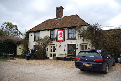
Photo: Nigel Chadwick · CC BY-SA 2.0 · Wikimedia Commons
Snargate
126 people lived here at the 2021 census, down 6.0% on 2011. It has 11 listed buildings, 1 of them Grade I.
- District
- Folkestone and Hythe
- Status
- Civil parish
- Size rank
- 338 of 364
- Grid
- 51.023°N, 0.837°E
01
Census
Population, 2001 to 2021
1122001
1342011
1262021
Source: Office for National Statistics census figures as recorded in Wikidata.
02
Heritage
11 listed buildings and 2 scheduled monuments
Most common types: church building, house, cottage, farmhouse, barn, archaeological site.
1Grade I
1Grade II*
9Grade II
2Scheduled
Grade I
Church of St Thomas à Becketchurch building · parish church · List entry 1277450
Grade II*
Church of St Dunstanchurch building · List entry 1061105
Grade II
Barn Circa 28 Yards West Of Old Farm Farmhousebarn · List entry 1277451
Barn Circa 50 Yards West Of Becket's Barn Farmhousebarn · List entry 1277481
Becket's Househouse · List entry 1061108
Cherry Tree Househouse · List entry 1061104
Church Cottagecottage · List entry 1231631
Old Farm Farmhouse And The Flat, Old Farmfarmhouse · List entry 1231667
Red Lionpub · List entry 1277477
Stonehouse Farmhousefarmhouse · List entry 1061107
Whitehall Cottagecottage · List entry 1061106
Scheduled monuments
Part of the Rhee Wall, a medieval canal, at Snargatearchaeological site · List entry 1010699
World War II underground operational base 500yds (457m) SW of Bentley Cottagescheduled monument · List entry 1003123
Source: National Heritage List for England entries recorded in Wikidata with this parish or town as location.
Twinned with
No twinning recorded.