Civil parish · Swale · E04005075
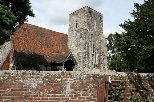
Photo: Jacqui Sadler · CC BY-SA 2.0 · Wikimedia Commons
Tonge
1,344 people lived here at the 2021 census, up 300.0% on 2011. It has 18 listed buildings, 1 of them Grade I.
- District
- Swale
- Status
- Civil parish
- Size rank
- 197 of 364
- Grid
- 51.352°N, 0.781°E
01
Census
Population, 2001 to 2021
2922001
3362011
1,3442021
Source: Office for National Statistics census figures as recorded in Wikidata.
02
Heritage
18 listed buildings
Most common types: farmhouse, house, cottage, granary, church building, barn.
1Grade I
2Grade II*
15Grade II
0Scheduled
Grade I
Church of St Gileschurch building · List entry 1322821
Grade II*
Bax Farmhousefarmhouse · List entry 1338557
Newberry Farmhousefarmhouse · List entry 1069267
Grade II
Barn 20 Yards North West Of Bunces Farmhousebarn · List entry 1121884
Beecheslisted building · List entry 1121878
Bunces Farmlisted building · List entry 1069269
Cheke Courtlisted building · List entry 1343948
Fox Cottagecottage · List entry 1121527
Granary 20 Yards South Of West Tonge Farmhousegranary · List entry 1343949
Little Radfieldlisted building · List entry 1343950
Old Mill and Mill Househouse · watermill · List entry 1069265
Radfield House And Railings To Forecourtlisted building · List entry 1069268
Stables 30 Yards East Of West Tonge Farmhousestable · List entry 1338157
Tonge Corner Farmhousefarmhouse · List entry 1069270
Tonge Millhouse · watermill · List entry 1338569
West Tonge Farmlisted building · List entry 1069266
Woodstreet Cottagecottage · List entry 1069271
Woodstreet Househouse · List entry 1121893
Source: National Heritage List for England entries recorded in Wikidata with this parish or town as location.
Neighbours
Twinned with
No twinning recorded.