Town · Thanet
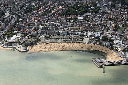
Photo: John Fielding from Norwich, UK · CC BY 2.0 · Wikimedia Commons
Broadstairs
Population 24,903.
- District
- Thanet
- Status
- Town
- Size rank
- 22 of 364
- Postcode
- CT10
- Grid
- 51.359°N, 1.439°E
- Council
- www.broadstairs.gov.uk
03
Schools
14 schools nearby
Open schools from the DfE register addressed in Broadstairs, or whose nearest town or parish centre in Thanet is Broadstairs.
| School | Phase | Ages | Pupils | Intake |
|---|---|---|---|---|
| Wellesley Haddon Dene School | Other independent school | 2–13 | 156 | Mixed |
| EKC Group | 16 plus | 14–99 | — | Mixed |
| Bromstone Primary School, Broadstairs | Primary | 4–11 | 407 | Mixed |
| Callis Grange Nursery and Infant School | Primary | 3–7 | 291 | Mixed |
| Ramsgate, Holy Trinity Church of England Primary School | Primary | 4–11 | 210 | Mixed |
| St Joseph's Catholic Primary School, Broadstairs | Primary | 4–11 | 151 | Mixed |
| St Mildred's Primary Infant School | Primary | 4–7 | 269 | Mixed |
| St Peter-in-Thanet CofE Junior School | Primary | 7–11 | 360 | Mixed |
| Upton Junior School | Primary | 7–11 | 515 | Mixed |
| Dane Court Grammar School grammar | Secondary | 11–18 | 1,152 | Mixed |
| St George's Church of England Foundation School | All-through | 4–19 | 1,590 | Mixed |
| The Charles Dickens School | Secondary | 11–18 | 1,117 | Mixed |
| Maple Tree Primary School | Other independent special school | 7–11 | 9 | Mixed |
| Stone Bay School | Foundation special school | 4–19 | 108 | Mixed |
Twinned with
Wattignies