- Home
- Canterbury
- Kingston
Civil parish · Canterbury · E04004879
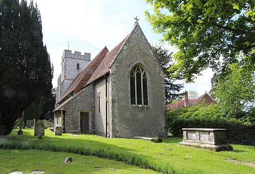
Photo: John Salmon · CC BY-SA 2.0 · Wikimedia Commons
Kingston
474 people lived here at the 2021 census, up 0.6% on 2011. It has 16 listed buildings, 1 of them Grade I.
- District
- Canterbury
- Status
- Civil parish
- Size rank
- 284 of 364
- Area
- 5.1 km²
- Grid
- 51.218°N, 1.149°E
01
Census
Population, 2001 to 2021
4442001
4712011
4742021
Source: Office for National Statistics census figures as recorded in Wikidata.
02
Heritage
16 listed buildings and 1 scheduled monument
Most common types: cottage, farmhouse, church building, archaeological site, stable, pub.
1Grade I
0Grade II*
15Grade II
1Scheduled
Grade I
Church of St Gileschurch building · List entry 1373855
Grade II
Ally Cottagecottage · List entry 1336575
Barn At Westwood Farmbarn · List entry 1085590
Black Robin Public Housepub · List entry 1049090
Granary At Westwood Farmgranary · List entry 1085591
Ileden Farmhousefarmhouse · List entry 1336573
Kingston Courtlisted building · List entry 1085585
Little Courtlisted building · List entry 1085584
Marley Farmhousethatched farmhouse · List entry 1085586
Railway Cottagecottage · List entry 1336574
Rectory Cottagecottage · List entry 1336553
Stables At Westwood Farmstable · List entry 1049044
Westwood Farm Cottagecottage · List entry 1393202
Westwood Farmhousefarmhouse · List entry 1336576
Whitelockslisted building · List entry 1085587
Whitelocks Farmhousefarmhouse · List entry 1085588
Scheduled monuments
Anglo-Saxon barrow field and prehistoric linear earthwork on Barham Downsarchaeological site · List entry 1013377
Source: National Heritage List for England entries recorded in Wikidata with this parish or town as location.
Twinned with
No twinning recorded.