- Home
- Canterbury
- Westbere
Civil parish · Canterbury · E04013519
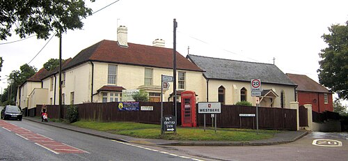
Photo: My another account ( talk ) · CC0 · Wikimedia Commons
Westbere
309 people lived here at the 2021 census, down 17.8% on 2011. It has 17 listed buildings, 1 of them Grade I.
- District
- Canterbury
- Status
- Civil parish
- Size rank
- 313 of 364
- Area
- 3.5 km²
- Grid
- 51.309°N, 1.141°E
01
Census
Population, 2001 to 2021
3682001
3762011
3092021
Source: Office for National Statistics census figures as recorded in Wikidata.
02
Heritage
17 listed buildings
Most common types: cottage, farmhouse, thatched cottage, church building, house, granary.
1Grade I
1Grade II*
15Grade II
0Scheduled
Grade I
Church of All Saintschurch building · List entry 1085482
Grade II*
Westbere Househouse · List entry 1367055
Grade II
26 And 28, Westbere Lanelisted building · List entry 1367084
Ashby Cottagethatched cottage · List entry 1085487
Barn And Granary To North East Of Walnut Tree Farmhousegranary · barn · List entry 1054868
Barn At Kemphall Farmbarn · List entry 1085485
Garden Wall To Westbere Housewall · List entry 1336607
K6 Telephone Kiosk At The Junction Of Bushy Hill RoadK6 telephone box · List entry 1241671
Kemphall Farmhousefarmhouse · List entry 1054876
Laurel Cottagecottage · List entry 1054846
North Cottageslisted building · List entry 1054840
Stable At East Of Walnut Tree Farmhousestable · List entry 1085484
Walnut Tree Farmhousefarmhouse · List entry 1336606
Westbere Cottagethatched cottage · List entry 1085488
Westbere Courtlisted building · List entry 1085483
White Cottage Yew Tree Cottagecottage · List entry 1085486
Ye Olde Yew Tree Innpub · inn · List entry 1085489
Source: National Heritage List for England entries recorded in Wikidata with this parish or town as location.
Twinned with
No twinning recorded.