- Home
- Tonbridge and Malling
- Wrotham
Civil parish · Tonbridge and Malling · E04005114
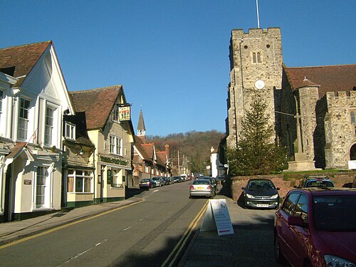
Photo: Clem Rutter, Rochester Kent · CC BY-SA 3.0 · Wikimedia Commons
Wrotham
1,961 people lived here at the 2021 census, up 2.1% on 2011. It has 64 listed buildings, 1 of them Grade I.
- District
- Tonbridge and Malling
- Status
- Civil parish
- Size rank
- 152 of 364
- Postcode
- TN15
- Grid
- 51.308°N, 0.308°E
01
Census
Population, 2001 to 2021
1,8152001
1,9212011
1,9612021
Source: Office for National Statistics census figures as recorded in Wikidata.
02
Heritage
64 listed buildings
Most common types: chest tomb, house, wall, farmhouse, cottage, stable.
1Grade I
4Grade II*
59Grade II
0Scheduled
Grade I
Church of St George, Wrothamchurch building · List entry 1236562
Grade II*
Ford Place And Wall To Northlisted building · List entry 1236317
The Old Palacelisted building · List entry 1236308
West Househouse · List entry 1264616
Wrotham Placelisted building · List entry 1264591
Grade II
1-3, High Streetlisted building · List entry 1236385
2, St Mary's Lanelisted building · List entry 1236511
Bank House Bank House, Old Bank House And Premises Adjoining To East Old Bank House And Premises Adjoining To Easthouse · List entry 1264586
Barn 100 Yards West Of Margaret Mcmillan Housebarn · List entry 1236362
Barn 30 Yards To The East Of Ivy Hall Farmhousebarn · List entry 1236559
Bishop's Lodgegatehouse · List entry 1236561
Boundary Wall To South And South-East Of Bishop's Lodgewall · List entry 1264543
Cedar Househouse · List entry 1264539
Chest Tomb 10 Yards East Of Church Of St Georgechest tomb · List entry 1236609
Chest Tomb 20 Yards South-East Of Church Of St Georgechest tomb · List entry 1264525
Chest Tomb 25 Yards South-East Of Church Of St Georgechest tomb · List entry 1236605
Chest Tomb With Panelled Sides 5 Yards South Of Church Of St Georgechest tomb · List entry 1236591
Chest Tomb With Reeded Corners 7 Yards South Of Church Of St Georgechest tomb · List entry 1236600
Cottage Row Comprising Angel Cottage And 3 To Rightcottage · List entry 1264562
Court Lodgegatehouse · List entry 1236483
Donkey Wheel House 70 Yards To The South Of Court Lodgelisted building · List entry 1264585
Dovecote 30 Yards South East Of Wrotham Placedovecote · List entry 1236447
Green Hill Househouse · List entry 1236631
Hognore Farm Housefarmhouse · List entry 1236510
House Immediately To West Of The Wrotham Shophouse · List entry 1236373
Ivy Hall Farmhousefarmhouse · List entry 1236558
Low Chest Tomb 10 Yards South Of Church Of St George South Porchchest tomb · List entry 1236583
Low Chest Tomb 10 Yards South Of Church Of St George South Porchchest tomb · List entry 1236587
Moat Cottagecottage · List entry 1236482
Moat Restaurantrestaurant · List entry 1236475
Monument 20 Yards South-East Of Church Of St Georgemonument · List entry 1236603
National Westminster Bank And 2 Premises Adjoining To Northbank building · List entry 1236655
Newhouse Farmhousefarmhouse · List entry 1236473
Normey Cottagecottage · List entry 1236552
Oak Cottagecottage · List entry 1245946
Pedestal And Shrouded Urn 15 Yards North-East Of Church Of St Georgelisted building · List entry 1236628
Railings 10 Yards To The North Of Sudbury Houseguard rail · List entry 1236675
Sandstone Cottage The Bower Househouse · List entry 1264608
Stable 15 Yards To North Of The Elmsstable · List entry 1236295
Stable 30 Yards To The North Of Ford Placestable · List entry 1236360
Stable Building 10 Yards To The North Of Wrotham Placestable · List entry 1274852
Stable Building 80 Yards North East Of Wrotham Placestable · List entry 1264600
Sudbury Househouse · List entry 1236670
The Almshousesalmshouse · List entry 1236528
The Bull Hotelhotel · pub · List entry 1264650
The Butchers Shoplisted building · List entry 1236550
The Elmslisted building · List entry 1236290
The George And Dragon Public Housepub · List entry 1264609
The Hollieslisted building · List entry 1236288
The Old Farmhousefarmhouse · List entry 1236554
The Old Vicarageclergy house · List entry 1236298
The Post Officepost office · List entry 1236401
The Three Post Boys Public Housepub · List entry 1236633
The Weavers And Shop Premises To Rightlisted building · List entry 1236410
The Wrotham Shoplisted building · List entry 1264641
Town House And East Lodgelisted building · List entry 1236684
Wall 100 Yards North Of Bull Hotelwall · List entry 1264639
Wall 40 Yards To The North East Of Ford Place, That Part In Addington Cpwall · List entry 1363079
Wall 40 Yards To The North East Of Ford Place, That Part In Wrothamwall · List entry 1236359
Wall 40 Yards To The North West Of Ford Placewall · List entry 1264630
Wall To South-West Of Church Of St Georgewall · List entry 1264510
Wall, Gate And Gatepiers 20 Yards To North Of Wrotham Placewall · gate · List entry 1274854
Wrotham Water Farmhousefarmhouse · List entry 1264482
Yaldham Manormanor house · List entry 1236457
Source: National Heritage List for England entries recorded in Wikidata with this parish or town as location.
03
Schools
3 schools nearby
Open schools from the DfE register addressed in Wrotham, or whose nearest town or parish centre in Tonbridge and Malling is Wrotham.
| School | Phase | Ages | Pupils | Intake |
|---|---|---|---|---|
| St George's Church of England Voluntary Controlled Primary School | Primary | 4–11 | 195 | Mixed |
| Wrotham School | Secondary | 11–18 | 1,054 | Mixed |
| Grange Park School | Foundation special school | 9–19 | 174 | Mixed |
Twinned with
No twinning recorded.